Have you ever heard of a trail called the Tour du Mont Blanc (TMB)?
The TMB is a long-distance hiking route that starts and ends in Chamonix, France, and traverses the mountains surrounding Mont Blanc—the highest peak in Europe—across three countries.
It is one of the most popular hiking trails in Europe, attracting hikers from all over the world every year.

From August 29 to September 7, 2024, I took on this hike myself over the course of 10 days. It turned out to be one of the most memorable experiences among all the hikes I’ve done so far, so I’d like to share it here.
Whether you love hiking or are not particularly interested in it, I hope this experience can inspire your future travel or trekking plans.
Itinerary Overview
| Day | Route |
|---|---|
| 0 | Arrival in Chamonix |
| 1 | Les Houches → Les Contamines |
| 2 | Col du Bonhomme |
| 3 | Les Mottets |
| 4 | Into Italy |
| 5 | Courmayeur |
| 6 | Into Switzerland |
| 7 | Champex |
| 8 | Trient |
| 9 | Montroc |
| 10 | Lac Blanc |
Day 0: Arrival in Chamonix (France)
To start the TMB early on Day 1 in the best possible condition, I arrived in Chamonix the day before.
From Amsterdam, where I live, it takes about 1.5 hours by plane to Geneva Airport, and then around 2 hours by bus to Chamonix.
During this season, many people come to the Alps for hiking, so it was common to see travelers carrying trekking gear at the airport.
Chamonix is well known for winter sports, but in summer it’s also a hub for hiking, climbing, mountain biking, and trail running.
When I arrived, there was even a trail running event happening, and the town was lively.
I stayed in an Airbnb in Les Houches, close to the starting point of the TMB. I checked my gear and went to bed early.

Day 1: Les Houches → Les Contamines-Montjoie
The first day of the TMB begins in Les Houches, heading toward Les Contamines-Montjoie.
First, I headed to the official start/finish gate of the TMB. I arrived around 8 a.m., and along the way I met several groups who were also starting that day.
We took photos for each other and chatted about where we were from—it was a great opportunity to meet people who would be sharing the journey.

About 10 minutes from there is a gondola station, which takes you up to Bellevue.
It is possible to hike up, but that would add about 6km and 700m of ascent, and since it was the first day, I chose to take the gondola. It was almost full at that time.
From the top, I followed the TMB trail signs into the forest. Since it was the starting section, there were quite a lot of people.

After about 1.5km, I reached a suspension bridge. It’s one of the highlights of the TMB, crossing a river fed by glaciers. Everyone carefully crossed while taking photos.

After crossing the bridge, the trail gradually climbs, leading to a saddle point. The scenery here was stunning, surrounded by mountains in every direction.
Continuing another 2km uphill, I reached the highest point of the day, Col de Tricot.

From there, it’s a relatively steep 2km descent to Refuge de Miage.
Some people took a lunch break here, but I continued further and rested at Refuge Auberge du Truc, located after another short climb.
The peaceful scenery with grazing cows made it a very relaxing spot.
After that, descending about 3km brought me to the town of Les Contamines-Montjoie.
There are restaurants and supermarkets here, so it’s a good place to buy anything you may have forgotten.

From the town, I walked another 3km along the river to reach the Gite le Pontet campsite area, where my accommodation for the night was located.
The campsite had plenty of showers and toilets and was relatively clean, making it comfortable to stay.
Dinner was served in the attached dining hall and included melon with prosciutto, baguette, stewed meat, and even a chocolate cake-like dessert—very satisfying.
The dormitory accommodated 37 people, divided into sections of about six people each with thin walls and no doors.
Because of that, conversations and snoring could be heard clearly, making earplugs essential from the very first night.
Day 2: Les Contamines → Col de la Croix du Bonhomme
On Day 2, I climbed 1,280m, crossing Col de Bonhomme and continuing to Col de la Croix du Bonhomme.
Starting from the campsite, the trail begins with a flat path along the river.
After about 1.5km, I reached a small church called Notre Dame de la Gorge.

Looking inside, it appeared to be an old and historic building, yet it was very well maintained.
From there, a relatively steep climb continues for about 2km until reaching a valley.
The path then becomes flat for a while, with beautiful scenery of rivers flowing from the mountains and peaks surrounding the trail.
Then came another uphill section. Since it was during the hottest part of the day, the climb felt quite tough.

After climbing about 5km with breaks, I reached the highest point of the day, Col de Bonhomme. The panoramic views from here were stunning.

It took about 3.5 hours to reach this point. After a short break, I continued onward.
After another 2km, I arrived at my accommodation for the night, Refuge de La Croix du Bonhomme.
The scenery here was also beautiful, but if you walk an additional 1.5km beyond the hut along a gentle slope, you can reach a peak called Crête des Gittes. The view from there was even more spectacular.

This section is not part of the main TMB route, so not many people went there, but someone I met at the previous accommodation recommended it, so I decided to check it out.
The peak is surrounded by valleys, with mountains stretching out in all directions—a landscape unlike anything else I had experienced. I could even see Mont Blanc from there.
As for the accommodation, this was the least comfortable mountain hut on the TMB.
Since all routes pass through here, it tends to be crowded, and many people I met also complained.
The dorm room had eight beds, but the beds creaked, the door was broken and left half-open, and it was difficult to sleep.
The toilets and showers were not very clean, and the showers required coins that only allowed about five minutes of use.
Although additional coins could be purchased, there were only two showers, so it was quite inconvenient.
The meal was something like a macaroni-based lasagna—not bad, but not particularly good either.
Also, the UTMB (Ultra-Trail du Mont Blanc) race happened to be taking place that night, and whenever runners passed by during the night, cheers could be heard, making it even harder to sleep.
Day 3: Col de la Croix du Bonhomme → Les Mottets
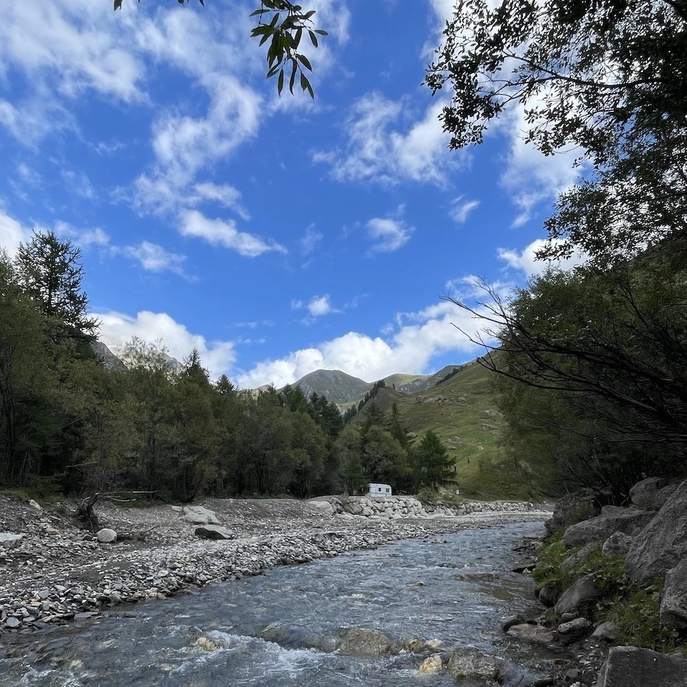
On this day, I walked back about 1.3km along the path I had taken the previous day, then took a different route at a junction and descended about 5km through a valley to a village called La Ville des Glaciers. From there, I walked about 1km along a gentle path to Refuge des Mottets, making it a relatively short section of just under 8km.
※ Another route exists where you go via a town called Les Chapieux and then climb up to La Ville des Glaciers, which seems to be the standard route.
This descent was long and fairly steep, and toward the end my knees started to feel shaky, but I carefully made my way down and managed to reach the accommodation safely.

I heard that marmots often live in this area, and I managed to spot about two of them.

Also, there is almost no mobile signal in this valley, so it’s something you should be aware of.
The place I stayed this day felt more like a lodge than a mountain hut. The restaurant and accommodation were separate, and the buildings were relatively new and well maintained.

The meal was plentiful and delicious, including bread, soup, salad, and sausages. The staff even played a hand-cranked music box-like instrument, which became a lovely memory.
The room was a 4-person dormitory, and as long as no one was snoring, it was a relatively comfortable environment to sleep in.
Day 4: Les Mottets → Rifugio Maison Vieille
On Day 4, I crossed from France into Italy, covering a section of about 18km.
From Les Mottets, I first climbed about 4km up to Col de la Seigne, where the border is located. This was also a fairly tough climb, and near the top the wind was strong, so proper rest and gear were essential.

Reached the summit. From here onward is Italy.

From here, descending gently for about the same distance brings you to Refuge Elisabetta. From around this area, you can see Mont Blanc and the surrounding glaciers, making it a spectacular viewpoint. It is also a perfect place to take a break while enjoying your first coffee after entering Italy.

From here, the TMB splits into two routes.
One is the route shown on the AllTrails map, which climbs a mountain called Arp-Vieille supérieure and traverses along it, and the other is a route that descends into the valley, follows a flat path, and then climbs a steep slope.
I was unaware of the first option and followed the second route based on a map provided by a tour company, but the final 3km of this section were extremely steep and tough. If I were to do it again, I would choose the first route.
The roughly 8km stretch of gentle descent and flat trail from Refuge Elisabetta was surrounded by mountains, with vivid blue rivers appearing in places, allowing me to enjoy beautiful scenery throughout.

After climbing a steep slope, I arrived at my accommodation for the night, Rifugio Maison Vieille, located on a hill.

Courmayeur, where this hut is located, is a ski resort in winter, so ski course signs could be seen everywhere.
This accommodation had Wi-Fi, delicious Italian food, wine and beer, and very friendly staff, making it one of my favorite places along the TMB. I would love to visit again during the winter ski season.
Day 5: Rifugio Maison Vieille → Rifugio Giorgio Bertone
On Day 5, I descended into the town of Courmayeur and then climbed up to my second accommodation in Italy, Rifugio Giorgio Bertone.
Both the descent and ascent were about 5km each.
Courmayeur is said to be the second largest town along the TMB, so it is quite lively. I enjoyed some gelato and good coffee, taking a bit of time to relax and feel like a tourist.


On the way to the hut, the trail enters the forest after passing through the town. There are several spots where you can look down over the town, and as I climbed higher and the town became more distant, it gave me a strong sense of accomplishment.

Arrived at Rifugio Bertone.

This day was also a relatively short section, so before check-in, I spent time outside resting, stretching, and walking around. Since the hut was located on a hill, just lying on the grass felt incredibly refreshing.
The staff were friendly and kind, creating a warm, family-run atmosphere.
There was one building with a 10-person dormitory and two buildings with private rooms. I was lucky enough to stay in one of the private rooms, and for the first time since Day 5 of the TMB, I was able to sleep soundly.
The building was new, warm inside despite the cold outside, and the toilets and showers were clean.
The food was also delicious, including pasta, sausage stewed in tomato sauce, and marinated beans.
Day 6: Rifugio Bertone → Alpage de La Peule
At this point, I had completed more than half of the TMB. This day included crossing Col Ferret, the highest point of the entire route, and entering Switzerland.
The route to Rifugio Bonatti was a gentle 7.5km traverse. On the left side, glaciers could be seen up close. Although the weather was cloudy and partially obscured the view, it was still an impressive sight.


After walking another 4km, there was a steep descent of about 1km leading to Chalet Val Ferret.
From there, climbing about 3km leads to Refuge Elena, the last rest point on the Italian side. Since the climb to Col Ferret is another steep 3km, I made sure to rest well before continuing.

After continuing upward, I finally reached Col Ferret, the border between Italy and Switzerland.

From there, I descended about 3.5km to my accommodation for the night, Alpage de La Peule.
This place is known for producing homemade cheese, and as I approached, I could hear the sound of cowbells.


As soon as I entered Switzerland, it started raining (apparently it rains often in Switzerland), and the temperature dropped.
My shoes got wet and did not dry easily. Being in the middle of the TMB, fatigue was also setting in, and some people were getting sick. It reminded me once again how important proper equipment is.
This accommodation was relatively comfortable despite being located deep in the mountains. There was a fireplace, so it was warm inside, and Wi-Fi was available. The only downside was that there were only two showers and two toilets, which could be inconvenient when crowded.
The food here was also excellent, including a fresh salad, baked bread with ham and cheese, and a fruit dessert.
The dormitory accommodated about 30 people, and I slept in the bottom bunk of a triple bunk bed.
The temperature was fine, but due to the large number of people, snoring was an issue. Earplugs didn’t help much, so I used noise-canceling AirPods to get some sleep.
Day 7: Alpage de La Peule → Relais d’Arpette
On this day, I walked through a town called La Fouly, then continued along a gentle valley trail, and finally climbed up to an area with a lake called Champex-Lac.
First, from the accommodation, I descended about 6km through the forest and arrived at La Fouly.

There are supermarkets and restaurants here, so some people stopped for a break, but since this day was quite long overall, I decided to keep going.
From there, I walked about 10km along a path following the river.

The trail was gentle, and although it felt long at times, I was able to enjoy it like a leisurely walk, passing through small villages and admiring old buildings and scenery along the way.

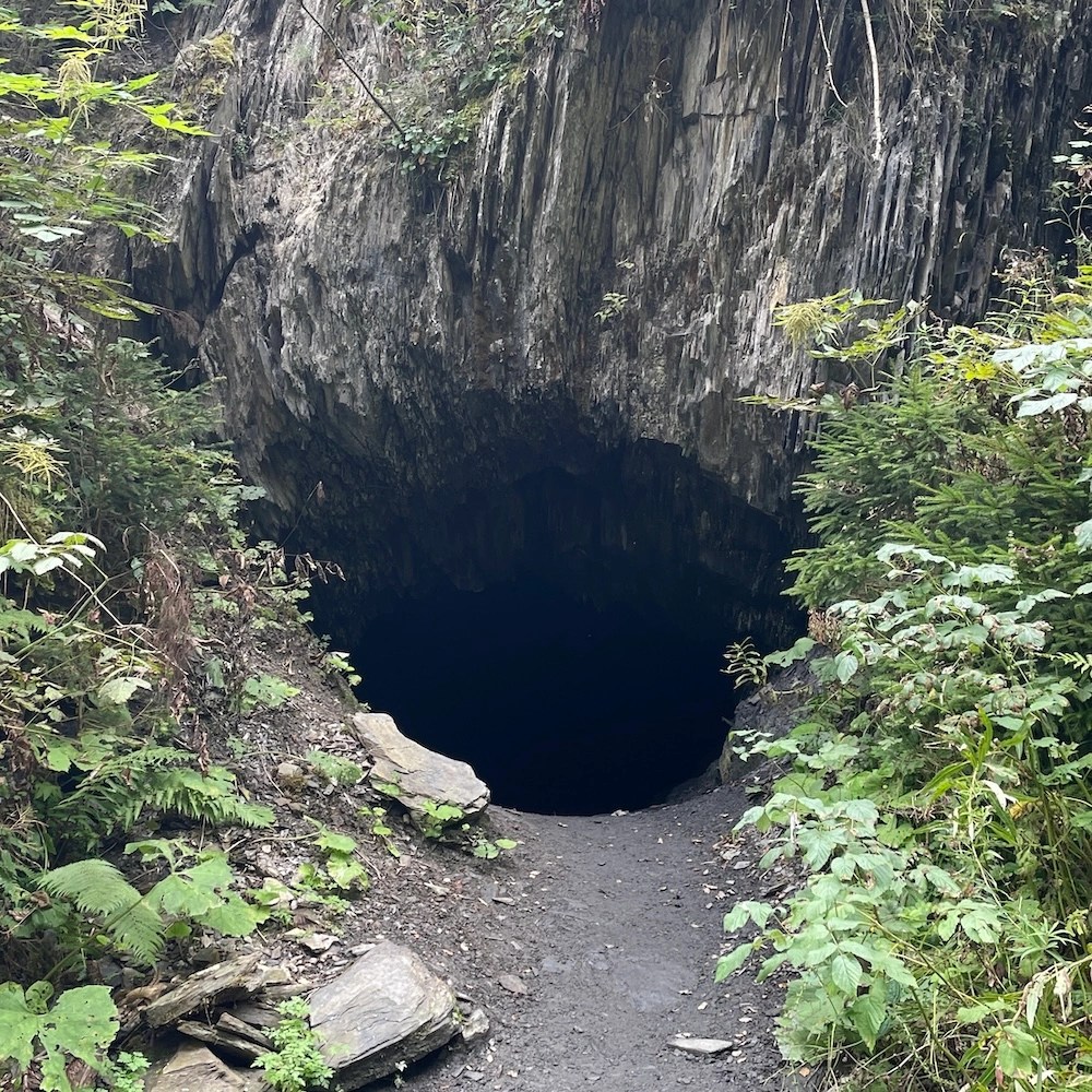
After passing an area called Issert, where restaurants line the road, I reached a trail leading up toward Champex-Lac. This trail had various sculptures along the way, which made the climb more enjoyable.
There was also a cave along the route, and going inside gave me a bit of an adventurous feeling.
After climbing about 4km, restaurants began to appear, and I finally arrived at Champex-Lac. The weather wasn’t great that day, but I imagine the lake must look even more beautiful on a clear day.

Walking along the lake and entering the trail again, I saw ski lifts and followed a path along a river uphill to reach my accommodation for the day, Relais d’Arpette.


The meal here was served buffet-style with unlimited salad and vegetable curry, which was very satisfying.
I was also lucky enough to have a 6-person room all to myself that night, so I was able to sleep very well.
Day 8: Relais d’Arpette → Trient
On this day, I walked through a point called Col de Portalo and headed toward a town called Trient.
There are two route options for this section: one via Col de Portalo and another via Fenêtre d’Arpette, which passes the highest point of the TMB at 2,700m and is said to offer better views.
However, unfortunately, it rained that day, and locals advised against taking that route in such conditions, so I chose the safer Col de Portalo route instead.
Considering that I only experienced rain on one out of the ten days, I think I was quite lucky overall.

After descending about 4.5km and then climbing around 6km, I reached Col de Portalo.
Near the summit, there is a hut called Alpage de Bovine, where many people took shelter from the rain. The plum pie I had here was incredibly delicious, and the warm tea after walking in the cold rain really helped warm my body.

From the summit, I walked another 6.5km to reach Trient, where I stayed at Auberge du Mont Blanc.


The meal here included soup, salad, cheese fondue, and ice cream for dessert—very satisfying and delicious.
There was also a sauna, which helped warm up my body after being out in the rain.
The room was an 8-person dormitory—nothing particularly special, but not bad either.
The only downside was that the Wi-Fi connection was quite unreliable. Since mobile data that works in other EU countries didn’t work in Switzerland, it was a bit frustrating.
Day 9: Trient → Montroc
With only two days remaining, I walked from Trient on the Swiss side back into France, heading toward Montroc.

After about 1km from the accommodation, I reached the trailhead, and from there climbed steadily for about 5.5km, gaining around 1,000m in elevation.
The climb didn’t feel extremely steep, but the many switchbacks made it feel longer.
There were also spots along the way where I could look back and see the town of Trient, which offered beautiful views on a clear day.

Continuing further, I reached Col de la Balme, which marks the border between Switzerland and France.

From here, surrounded by mountains in every direction and with a clear view of Mont Blanc, people took photos together to commemorate the moment.
Since the weather was very good and I had some extra time, I also decided to climb a nearby peak called Croix de Fer.


Although it is not part of the TMB route, the view from here was arguably the best of the entire journey, so I’m really glad I went.
From there, I descended gently for about 2km, climbed again for 1km, and then descended continuously for about 4km.

As I descended, buildings gradually came into view, and I arrived at my accommodation for the day, Gite Le Moulin.

This place was very comfortable, with no time limit on the showers and stable Wi-Fi.
The food was also excellent, including marinated carrots, roasted vegetables with prosciutto and pasta, and plum cake.
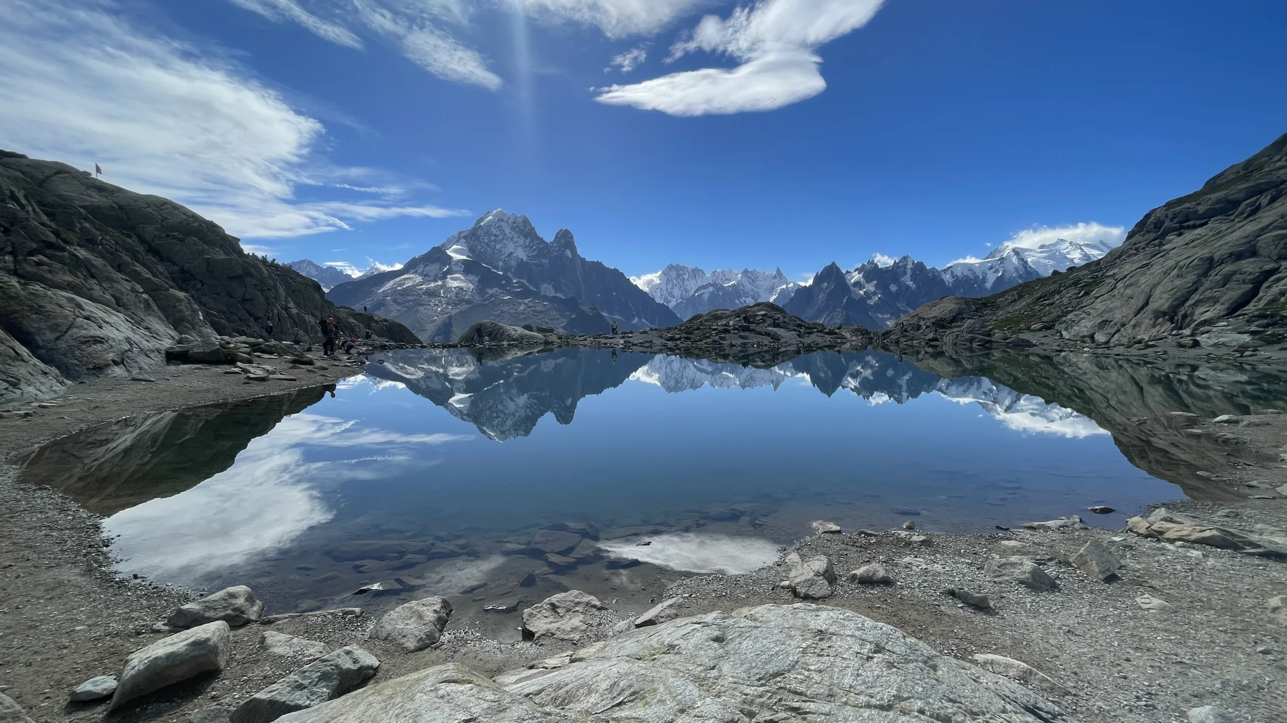
Day 10: Montroc → Col du Brévent
On the final day, I climbed through the mountains of Chamonix, aiming to see Mont Blanc reflected in Lac Blanc before descending.
This day involved about 1,280m of ascent over 14km, making it quite a long and demanding final stretch, so I set off early in the morning with determination.


The first 5km was a continuous uphill climb, with some steep sections and even a section where I had to climb a ladder of about 20 meters, making it slightly dangerous.
As I climbed higher, the wind became stronger, which was nerve-wracking, but I proceeded carefully and managed to reach the top safely.

The view at Lac Blanc was truly breathtaking, and since it was the final day, I ended up sitting there for about three hours.

There is also a mountain hut nearby where you can take a break. Since it is accessible by gondola partway, it gradually became crowded with tourists, so I was glad I started early.
From there, I descended about 9km along a gentle downhill path toward Col du Brévent, using my remaining energy to finish the hike.


From there, I took a gondola down to the town of Chamonix.
Summary
This was my first time attempting a long-distance hike of this scale, but I found that even beginners can complete it if they prepare properly in advance with research, training, and the right gear.
Being surrounded by incredible scenery throughout the trail made it an enjoyable experience from start to finish without ever feeling bored, making it a great option even for those new to long-distance hiking.
Along the way, I met people of all ages, genders, and nationalities. Hearing about their past hiking experiences and their reasons for joining the TMB inspired me to set new goals for myself and gave me the opportunity to make friends from around the world. In that sense as well, it was a truly valuable experience.
I have also summarized how to plan and prepare for the TMB in the article below, so please check it out as well.

If this article has sparked your interest, I highly recommend checking out the official TMB website and the trekking agency I used:
TMB Official: https://www.autourdumontblanc.com/en/routes/all-routes/tour-du-mont-blanc
bookatrekking: https://bookatrekking.com/en/trek/tour-du-mont-blanc-10-days/