The West Highland Way (WHW) is Scotland’s most celebrated hiking trail. With no major technical challenges, it welcomes a wide range of people — from seasoned hikers to those taking on their first long-distance walk.
This is my account of completing the entire route in August 2025, camping in a tent at every stage.
Day 0: Glasgow
I arrived in Scotland the day before the start and spent one night in Glasgow. Rather than heading straight to the starting point in Milngavie, I chose Glasgow for its better shopping options to stock up on food and supplies. As Scotland’s largest city, it’s full of tourist spots, shops, and restaurants — a great place to spend a day or two.
Day 1: Milngavie → Drymen
From Glasgow’s Queen Street station, I took the train to Milngavie (spelled “Milngavie” on Google Maps but pronounced “Milguy”), arriving around 10am.

A 10-minute walk through the town’s main street brings you to the official start of the WHW.

At the starting point, fellow hikers cheered each other on, and locals wished us “Good luck!” — it was a motivating start.
Day 1 covers 19km with 413m of elevation gain — essentially flat.
The first 3km pass through Mugdock Country Park, then through Carbeth, followed by farmland.


You’ll pass the Glengoyne Distillery, and a bit further along, cafés like “The Beach Tree” and “Turnip the Beet” make great rest stops.


The day’s campsite was Drymen Camping — not huge, but with clean showers and kitchen facilities.

Day 2: Drymen → Rowarden (Rowardennan)
23.5km, 699m of ascent.
The route passes through Garadhban Forest before opening into farmland, then climbs Conic Hill.


From the summit, the views of vast Loch Lomond (so large it looks like the sea) and the surrounding mountains are stunning. This spot is popular with locals too.

Descending 2km brings you to Balmaha, a lively village with a visitor centre, cafés, and souvenir shops. The gelato here is highly recommended on a sunny day!

From there, it’s 12km along the lakeshore to the campsite Lochan Maoil Dhuinne.

I took a quick break at Cashel Campsite, which is about 5km from Balmaha.

You’ll get to Lochan Maoil Dhuinne in 6km from the Cashel Campsite — essentially wild camping right by the beach. Absolutely beautiful, and my favourite overnight spot on the whole trail.


Note that this area requires a camping permit in advance: https://www.lochlomond-trossachs.org/things-to-do/camping/get-a-permit
Day 3: Rowardennan → Inverarnan
23km, 490m of ascent.
This section continues north along Loch Lomond on a narrow forest path. Rocks and tree roots jut out, so take care after rain.


About halfway, you reach Inversnaid, where a hotel serves snacks and coffee — perfect for a break.


Towards the end of the route, about 4km in, there’s a continuous uphill climb from the lake towards the mountains, but after about 2km it becomes downhill, and when you see a bridge, you’ll find the Beinglas Campsite just ahead.

The campsite Beinglas Campsite is spacious and even has glamping pods, but it suffers from a serious midge (tiny biting insect) problem — a well-known hazard in Scotland during this time of year. Essentials: “Smidge” insect spray and a midge head net. The only real defence is to keep moving — don’t stand still when pitching your tent.
Day 4: Inverarnan → Bridge of Orchy
The longest day: 30.4km, 1,094m of ascent.
Passing through the midpoint of Crianlarich, the route crosses pastoral valleys with sheep all around.


You’ll see the sign to Crianlarich, which is the halfway point of WHW.

You might spot the famous Highland cattle along the way.

After stopping at Tyndrum (20km in), I pushed on a further 10km to Bridge of Orchy — through heavy rain that left my shoes completely soaked.
Rain is very common in Scotland. Out of the week I was there, only 2 days were completely dry. Good rain gear and a smart clothing rotation strategy are absolutely essential.


You’ll see the Bridge of Orchy train station in about 10km from Tyndrum.

I wild camped at this public camping area by the bridge.
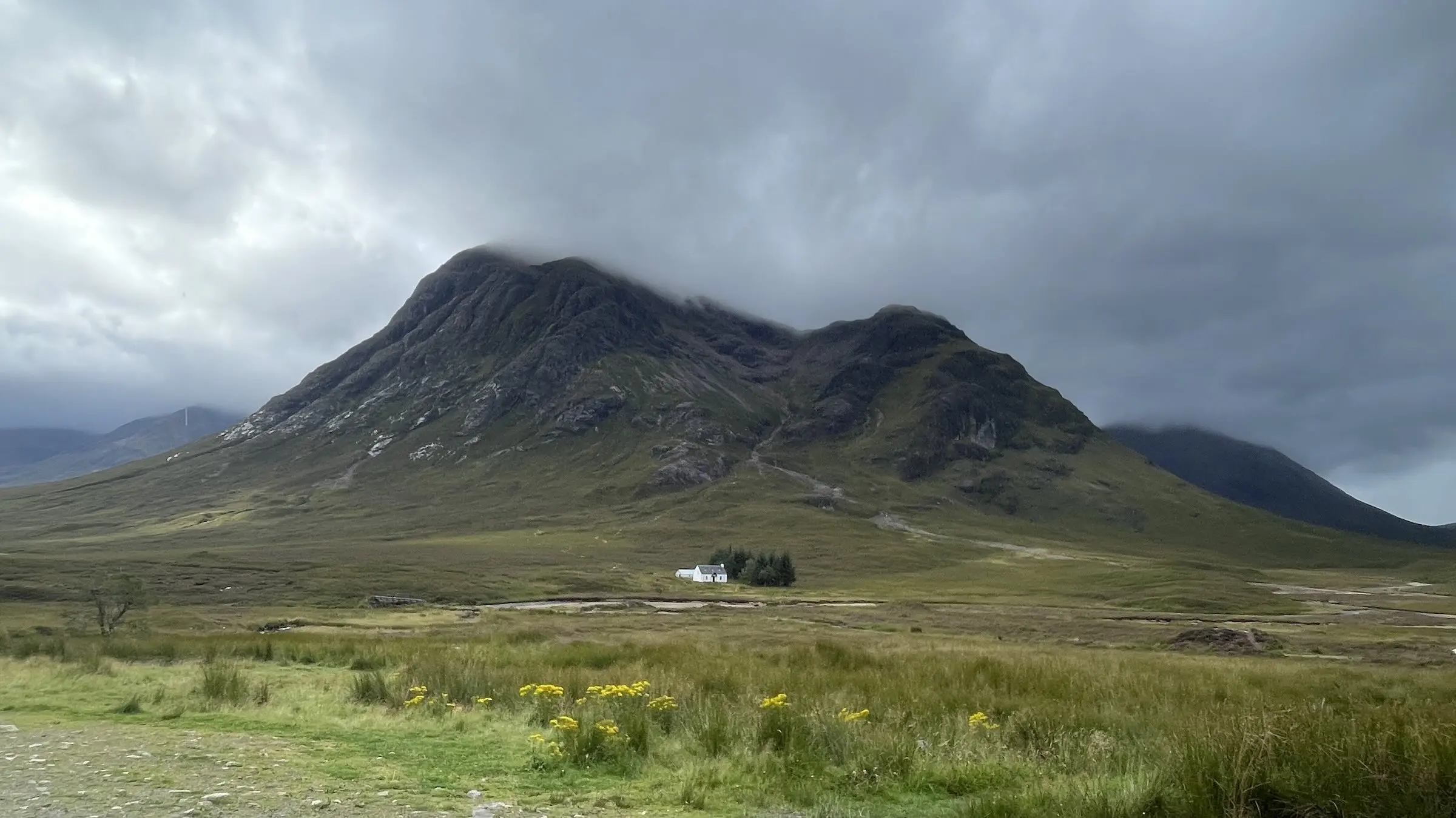
Day 5: Bridge of Orchy → Kingshouse area
19.6km, 876m of ascent.
The view of Loch Tulla from a hill 2km in was wonderful.


Further along, Inveroran Hotel offers some snacks and friendly service. You can also find a water tap outside.

The afternoon brought rain and wind with little shelter, so I walked straight through to Glencoe Mountain Resort Campsite (2–3km before Kingshouse).


It operates in summer alongside a ski lift and restaurant. Paid showers (£2 for 5 minutes) and a drying room for wet gear made it very comfortable.
Day 6: Kingshouse → Kinlochleven
15km, 523m of ascent — shorter in distance, but home to the famous Devil’s Staircase, the highest point on the entire WHW.
This section passes through the dramatic Glen Coe landscape, making it the scenic highlight of the trail.


After descending from Kingshouse and walking along Glen Etive, the route climbs the 2km-long Devil’s Staircase. It sounds intimidating but is very manageable — the main challenge is keeping warm in rain and wind, not the gradient itself.


Kinlochleven, the penultimate stop, is the largest village since the start, with restaurants and pubs.

The campsite Blackwater Hostel, Glamping & Campsite has clean toilets and showers, but midges were absolutely rampant here (possibly the worst on the trail). The outdoor kitchen area made cooking difficult, so I ate in my tent.
Day 7: Kinlochleven → Fort William
The final day: 24.8km, 825m of ascent.


The first 2km climb steeply, then flatten out for about 15km with gorgeous views of lakes framed by mountains.

There’s even a photogenic ruin along the way.

As Scotland’s highest peak, Ben Nevis, comes into view, you know the end is near.


After descending into Fort William on the final 8km stretch, the original WHW finish sign appears in town.

The current official finish is 1.5km further into the town centre, where the “Sore Feet” bronze statue awaits for a celebratory photo.

Day 8 (Bonus): Ben Nevis
Not wanting to leave without climbing Scotland’s highest mountain, I tackled Ben Nevis the following day — without my heavy pack!
The wind was ferocious, making it hard to stay upright. The weather was unstable: clear at the base, wet near the summit.
To get to the trailhead from Fort William: walk 40 minutes, or take a bus to the Youth Hostel (10 min) then walk 15 minutes. The trail starts at a bridge beside the visitor centre.
After crossing the bridge and passing the pasture, the path gradually becomes uphill. The incline isn’t too steep, and you can enjoy the changing scenery as you walk.

After about 4km you reach the saddle and “Halfway Lochan” (a small pond). From there it gets very windy.


The final stretch is a rocky zigzag to the summit — spectacular, but make sure to check wind conditions, not just the weather forecast.


Summary
The West Highland Way is a trail that lets anyone experience the beauty of Scotland’s nature. You can plan it at your own pace and level — it’s equally rewarding for beginners and those wanting a new kind of adventure.
For me, it was my first ever backpacking experience, and I’m so glad I chose this trail. Beyond the hiking itself, camping along the way gave me a much more self-sufficient and immersive experience of the natural world.
This page provides an overview of this hike, including approximate costs and the best time to visit, so please be sure to check it out.

Leave a Reply